
Carrito de compra
Su pedido cuenta con 0 productos
Envío gratis a partir de $389.00 (Consulta T&C)
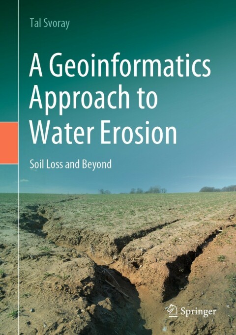
| ISBN: | 9783030915360 |
|---|---|
| Formato: | ePub |
| Idioma: | Inglés |
| Editorial: | Springer Nature |
| Tema: | Ciencia |
| Subtema: | Ciencias de la Tierra geografia |
| Año de publicación: | 2022-02-17 |
Degradation of agricultural catchments due to water erosion is a major environmental threat at the global scale, with long-lasting destructive consequences valued at tens of billions of dollars per annum. Eroded soils lead to reduced crop yields and deprived agroecosystem functioning through, for example, decreased water holding capacity, poor aeration, scarce microbial activity, and loose soil structure. This can result in reduced carbon sequestration, limited nutrient cycling, contamination of water bodies due to eutrophication, low protection from floods and poor attention restoration—consequences that go far beyond the commonly modelled soil loss and deposition budgets. This book demonstrates, using data from the Harod catchment in northern Israel, how cutting-edge geoinformatics, data science methodologies and soil health indicators can be used to measure, predict, and regulate these major environmental hazards. It shows how these approaches are used to quantify—in timeand space—the effect of water erosion not only on the soil layer, soil minerals, and soil loss, but also on the wide-range of services that agricultural ecosystems might supply for the benefit and well-being of humans. The algorithms described in this book play a major role in this paradigm shift and they include, for example, extraction of photogrammetric DEMs from drones data, advanced drainage structure calculations, fuzzy process-based modelling and spatial topographic threshold computations, multicriteria analyses and expert-based systems development using analytic hierarchal processes, innovative data-mining and machine learning tools, autocorrelation and interpolation of soil health, physically-based soil evolution models, spatial decision support systems and many more.







 Este sitio web utiliza cookies para mejorar la experiencia del usuario y asegurar su funcionamiento con eficacia.
Al utilizarlo usted acepta el uso de cookies.
Este sitio web utiliza cookies para mejorar la experiencia del usuario y asegurar su funcionamiento con eficacia.
Al utilizarlo usted acepta el uso de cookies.